by Leon Norsworthy
Every day in Australia tens of thousands of passengers fly safely and
confidently by virtue, in part, of the precision, accuracy and reliability
of the navigation aids that delineate our airways and provide approach
paths to many aerodromes. However, these admirable characteristics are
neither easily nor cheaply maintained. In the following article Leon
Norsworthy, Assistant General Manager of the CAA Flying Unit based
at Essendon Airport, Victoria, explains the role of his organisation and
sets out the reasons for the use of what some might see as possibly a
too large and too high-tech aircraft, the F28.
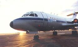
The blue and white aircraft of the CAAs fleet are a fairly familiar sight at many airfields around Australia, as they go about their tasks of route surveying, providing currency flying for CAA specialist pilots and transporting officials around the country on their various technical, operational, surveillance and examining duties. The most common CAA aircraft to be seen by the average General Aviation pilot is either the Beech 35 or 36, or the Gulfstream 1000 turboprop light twin. However, the other CAA type, although there are only two in the fleet, is much wider ranging and puts in regular appearances at many Australian airports. This is the Fokker F28 twin jet, which is primarily used for the calibration of Australias civil and defence aeronautical radio-navigation aids.
The contract to purchase the F28s was signed in 1974 and the first aircraft was delivered during December 1976. The choice of F28 aircraft was influenced by the following factors:
(1) an equipment load of up to 3000 kg to calibrate all civil/military airways facilities;
(2) forward-facing consoles;
(3) fitment of up to 50 antennae;
(4) large underfloor cargo area to carry support equipment and ground tracking systems;
(5) low tyre pressure for the aircraft to operate from unsealed runways;
(6) aerodrome performance to access 1600 metre runways;
(7) high cruising speed in the order of Mach 0.7 (420 kt) and range sufficient to reach Perth (2871 km) or Darwin (3171 1/4 km) from Melbourne with only one refuelling stop;
(8) good low speed handling and go-around performance from very low altitude;
(9) compliance with the noise standards; and
(10) program cost.
In the 1970s, the F28 surpassed its competitors in complying most closely with the criteria and was a natural selection. In the intervening years, the criteria have changed little; for example, the equipment load is now about 2500 kg. The F28 has proved to be an excellent choice and since its introduction 13 years ago has been more than satisfactory in performing calibration and flying training tasks. Moreover, the economic predictions based on operating this highly reliable and utilitarian aircraft continue to be fulfilled through the achievement of major program cost reductions over the years. The F28s, along with the rest of the fleet, give excellent value for money.
There are over 800 navigation aids in Australia and PNG for which CAA holds in-flight calibration responsibility, including a few privately-owned facilities and those operated by the Department of Defence at the various RAAF and RAN bases around the country. Each facility has to be checked, not only on a routine basis with time intervals varying from six months to two years, but also to reinstate an aid following modification, primary component change or failure.
As part of the current installation, there are a total of 39 dedicated
flight inspection antennas fitted to the aircraft to inspect the performance
of NDB, DMEA, DMEI, TACAN, LLZ, GP, VOR,
MKR, SSR together with VHF and UHF communications facilities. In addition,
the aircraft can be used to calibrate GCA/PAR and VASIS,
although these facilities do not require any specialist electronic equipment
apart from discrete VHF/UHF communications, and ground tracking equipment
(e.g. theodolite).
The F28s are operated by the CAAs Flying Unit, from its Headquarters at Essendon Airport in Victoria. Calibration missions can last up to ten days, covering the Australian FIRs from Cocos Island in the West to Norfolk Island in the East plus Papua New Guinea on a contract basis.
Routine calibration methods for NDB and DME do not call for any particular operational techniques. The aircraft is usually flight-planned to pass within range of the nominated facility and the various signal characteristics are recorded and compared against previous results to detect any change. If a fault is detected, the ground technical staff responsible for the aid are advised, and they rectify the defect. With some of the remote sites, the technical staff can be several hundred kilometres away by road, and in such cases a repeat flight is arranged to coincide with their presence at the site to confirm that the defect has been corrected.
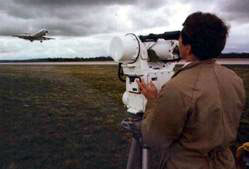
This tracker, which was developed in-house by the then Department of
Civil Aviation, uses a vidicon (light-sensitive video receiver) to track
a high-intensity, gyro-stabilised light on the nose of the calibration
aircraft, and can measure angular displacement to within .01 degrees.
The tracker is set up near the ground antenna of the element to be measured,
and tracks the calibration aircraft as it makes a series of approaches.
Movement of the tracker head as it follows the aircraft is converted to
a digital signal and then telemetered back to the aircraft on a discrete
VHF channel where it is compared electronically to the incoming signal
from the Localiser or Glide Path and the results recorded on a multi-channel
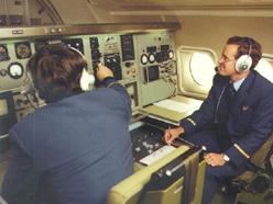
recorder. As the flight test progresses, the Flight Surveyors at the consoles
monitor the results and advise the ground party of any adjustments which
may be required. A typical routine flight test of a Localiser or Glide
Path will require from eight to twelve approaches and consume some 75
to 90 minutes flight time, with every alternate flight test (annual) being
carried out in greater detail, measuring more parameters and requiring
additional approaches.
The piloting and measuring tasks require a high degree of concentration and teamwork within the crew, not to mention a high degree of precision and skill on the part of the pilots. As can be appreciated, the presence of faults and delays caused by other traffic can extend the flight time. For one survey at a two-ILS major airport the requirement was to do a routine check on one installation and an annual check on the other. Several adjustments were necessary in the navaids, which resulted in the crew performing no fewer than 73 ILS approaches in two and a half days.
VOR calibration is less complex, but the technique still requires the use of an independent ground-based measuring device in the form of a very accurate pilot-balloon theodolite. The theodolite is set up at a previously surveyed position near the VOR and the calibration aircraft flies an orbit around the site at a radius of six nautical miles and an altitude 2000 ft above the site elevation. The altitude can vary for particular sites, depending upon local terrain; at Cairns for example, the orbit is flown at 4000 ft and the site elevation is almost at sea level. As the aircraft is flown around the VOR, it is tracked with the theodolite by the ground party, and the magnetic bearing is called, on a discrete VHF frequency, every ten degrees. The bearings are compared with those radiated by the beacon and received by the air craft and the results recorded and compared with those found on previous tests. The orbit establishes the basic alignment of the beacon and, if necessary, adjustments are made to bring the system into tolerance. At the completion of the orbit the calibration aircraft then flies a series of route radials out to a distance of 12 to 15 nm, to check such parameters as course quality, bending, scalloping etc while being tracked with the theodolite. Bearings are again called by the ground party and compared with the data received in the aircraft. Up to twelve radials will be flown, selected from the published routes, to provide a representative picture of the facility through 360°.
From the test crews point of view, ILS and VOR calibration work is the most intensive part of their duties, requiring considerable concentration for comparatively long periods of time. Calibration of TACAN and GCA is also demanding, as they are variations on the ILS/VOR theme.
All ILS installations in Australia are situated within controlled airspace, at least at those periods when they will be calibrated. With the willing co-operation of ATC, traffic separation is rarely a problem, and ATC will, where possible, fit the calibration aircraft into the traffic pattern to enable the task to be completed with the minimum delay and the maximum efficiency. The same situation applies with checking VORs within controlled airspace. However, many Australian VORs are sited outside controlled airspace, where the responsibility for traffic separation rests with the individual pilots.
Calibration operations OCTA place significant extra demands on the crew, as they not only have to concentrate on the calibration task, with its demands for precise flying, but they can be required to monitor up to three communications frequencies, as well as look out for, and keep mental track of other aircraft in the vicinity. Over the years, there have been occasions when separation standards have broken down. The message for all pilots flying OCTA is, of course, to keep your eyes open at all times, but to pay particular attention when operating in the vicinity of any navigation aid, which by its very nature, will act as a focal point for air traffic. Even if it is not required by the VFG/AIP, dont hesitate to broadcast your position and intentions if you think it may help some other airspace user. The CAAs F28 flight inspection crews welcome early traffic notifications.
The task of navigation aid calibration is important to all sections of the aviation industry, from the international Boeing 747 operator to the Aero Club or Flying School student pilot, yet it is probably fair to say that few pilots have ever given it much thought. The calibration crews perform a valuable quality assurance task, so that when you, the pilot, tune in a beacon and correctly identify it, you can be sure that it is feeding you the right stuff.
A recent audit of the task recommended:
(a) A complete review of flight survey procedures and techniques of existing facilities and the introduction of procedures, techniques and standards for anticipated new facilities e.g. MLS. This is expected to result in fewer hours being flown to obtain the same results as are achieved at present.
(b) Upgrading
of flight inspection measuring systems to automatic systems with the following
prospects:
(i) less payload requirement (a reduction in total payload from 3000 kg
to 1560 kg)
(ii) less space required for racks/consoles (decrease from 6 cu.meters
to 2.7 cu.metres)
(c) automatic systems to analyse more data and give instantaneous results with less man-power requirements (one Flight Surveyor for enroute aid checks and two Flight Surveyors for ILS/MLS checks as against the present survey crew of three).
However, new systems are costly and range from $3.0M to $5.0M per system without spares, laboratory and introductory costs. Technical and operational evaluations are underway which, when complete, will lead to an economic and financial analysis of the best airborne system and aircraft combination to satisfy Australias requirements into the next century.
A final word - any time you see one of the blue and white F28s on the ground at any airport, go up and introduce yourself to the crew. Theyll make you feel at home, and will be happy to show you over their aircraft and explain their job. If youre lucky, you might even score a cup of CAA coffee!
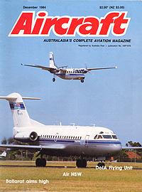
The Flying Unit made the cover of Aircraft's December 1984 issue. The magazine also contained a profile of the Unit's activities.
In 1997 the last remaining F28, VH-ATG, was withdrawn from service and replaced by IAI 1125 Astra VH-FIS and a Beech Super King Air, both operated on contract to Airservices Australia by Pearl Aviation. The Flying Unit was closed.
Back to the main Flying Operations
index