by Egon Stern
A
recently held divisional meeting of the International Civil Aviation Organisation
(ICAO) recommended INTERSCAN as the future standard precision approach and landing
system for international civil aviation. The issue was hotly contested and the
ICAO decision has received wide media coverage.
There was to have been no competition. ICAO invited Member States to develop new systems in a spirit of cooperation, with the interests of international civil aviation foremost in mind. Co-operation was indeed achieved in developing the operational requirements a new system had to meet and in framing system evaluation criteria. However these requirements could be met in many ways; system designers were deliberately left much latitude and inevitably competed with each other. When Australia decided in 1973 to develop a system for submission to ICAO, she entered into a contest with some of the world's most advanced technologies: the USA, the UK, France and the Federal Republic of Germany. It was no mean feat to succeed against such competition, and with comparatively small resources.
INTERSCAN will gradually replace the present standard Instrument Landing System (ILS) which is now installed at international airports and at many domestic airports, throughout the world. ILS provides instrument guidance by defining a course line in space. Aircraft guided manually or automatically by reference to the ILS descend to a height from which a visual landing can be made. This height depends on visibility criteria, on the terrain near the airport and on the nature of the ILS ground facilities and the airborne equipment. The most highly developed ILS facilities permit descent to touch-down in zero visibility.
ILS has served civil aviation well and will continue to do so for many years but the system has fundamental shortcomings which are increasingly felt and demand its eventual replacement. ILS defines a single approach path only, along the extended runway centre line and at a fixed angle of descent, usually 3°. The system cannot be used to guide aircraft on precisely defined segmented or curved approaches to the runway. At busy airports such approaches are increasingly needed to facilitate the control of the terminal traffic and to avoid noise-sensitive areas or terrain obstructions. ILS cannot be used by VTOL or STOL* aircraft which descend at angles steeper than 3°. The system is quite sensitive to reflections from terrain and buildings which disturb the course and may make it unflyable. ILS operates in the VHF frequency band and large, flat areas are needed to obtain a satisfactory performance. Very costly earthworks may be required and at some airports ILS cannot be made to work. These and other shortcomings motivated ICAO to recommend to Member States the development of a new system that can serve international civil aviation to the end of the century and beyond.
* VTOL=Vertical Take-Off and Landing, STOL=Short Take-Off and Landing
Basic Principles
INTERSCAN,
in contrast to ILS, provides precision guidance in a large part of the terminal
air space; it is, in effect, a precision terminal navigation system as well as
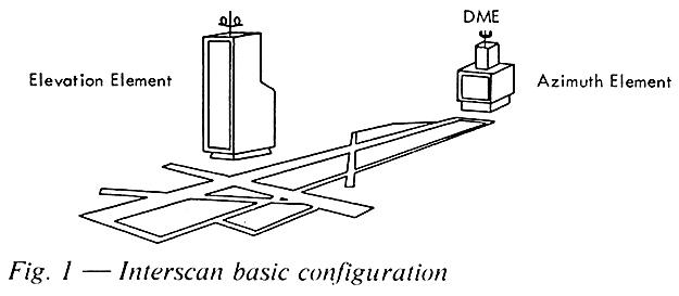
an approach and landing system. The INTERSCAN ground facilities define a co-ordinate
system in space and the aircraft's position in this reference frame is fixed by
means of the INTERSCAN airborne equipment. The three space co-ordinates, i.e.
azimuth angle, elevation angle and distance from a reference point on the airport,
are generated by separate sub-systems. (See Fig. 1): the forward azimuth sub-system
located beyond the runway stop-end, on the extended centre line and radiating
in the approach direction defines azimuth position; the elevation sub-system,
located to one side of the runway and also radiating in the approach direction,
defines the elevation angle; and a DME (Distance Measuring Equipment) beacon,
co-located with the azimuth element supplies slant distance from that point. The
range of these systems is approximately 30 nautical miles.
INTERSCAN
provides for two further guidance systems. A flare sub-system located near the
elevation element gives guidance in the final landing stage, prior to touch-down.
A missed-approach azimuth sub-system located ahead of the runway threshold and
radiating towards the stop-end provides guidance for missed approach manoeuvres.
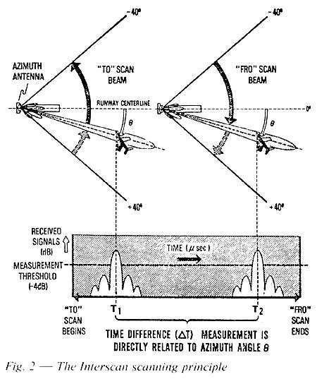
INTERSCAN
is based on the principle of time INTERval SCANning. In the USA the generic term
Time Reference Scanning Beam (TRSB) is commonly used for such systems, where angular
position in azimuth and elevation is determined by means of narrow, fan-shaped
beams. The INTERSCAN beams sweep TO and FRO, the azimuth beam through an angle
of +/- 40° referred to the runway centre line, the elevation beam up and down
from near zero elevation to an angle of 15°. As the beams intercept the aircraft,
signal pulses are received by the airborne equipment. Since sweep rates are precisely
controlled the time interval between the TO and FRO pulses is a measure of the
aircraft's angular position in azimuth and elevation. (See Fig. 2). In another
version of the elevation sub-system
the scanning beam is not fan-shaped but forms an inverted conical surface, co-axial
with the elevation antenna with apex at ground level.
The
angular sub-systems radiate sequentially, in a time multiplexed signal format.
An identifying preamble precedes the radiation from each sub-system. Further data
appertaining to the system as a whole and to the airport are transmitted in a
separate time slot.
The Distance Measuring Equipment is a precision version of the standard ICAO DME and operates in the L-band (980 to 1080 Mhz). A short pulse from a transmitter carried in the aircraft is received by the DME ground beacon and triggers a reply pulse from the beacon transmitter which is received in the aircraft. The airborne equipment measures the time interval between the transmitted and the received reply pulse. This interval is a direct measure of slant distance from the beacon. The system and equipment modifications were developed to increase system accuracy so as to make it commensurate with that of the angular sub-systems.
Antenna innovations
The C-band (5030 - 4090Mhz) was chosen for the INTERSCAN angle sub-systems, hence the name Microwave Landing System (MLS). The choice was dictated by the desire to achieve a narrow beam with small antennas and vet to avoid the heavy signal attenuation that would be encountered at higher frequencies with rainfall rates common in Australia. These microwave antennas are at the heart of INTERSCAN. Much effort has gone into the development of microwave antennas and the associated feed and switching systems and Australia's success is in no small measure due to the lead gained in this field.
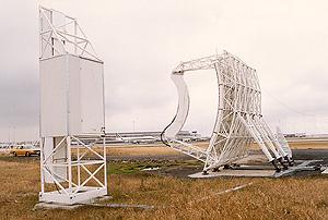
Antenna development was pursued and has progressed here in two directions. The experimental INTERSCAN system installed at Melbourne (Tullamarine) airport in 1974 employs reflector-type antennas for the azimuth and (planar) elevation sub-systems. (See Fig. 3).
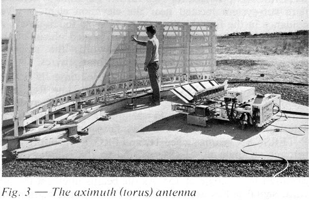
A
torus-shaped mirror is illuminated by waveguide feeds mounted on a circle with
radius half that of the torus reflector. A commutating system switches power sequentially
to the feed elements which progressively illuminate sections of the reflector.
(See Fig. 4).
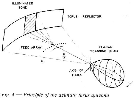
A
quasi-continuous scan is produced by energising several adjacent feed elements
simultaneously and progressively. The illuminated torus section deviates negligibly
from a perfectly collimating parabolic surface. Torus antennas therefore produce
a fan-shaped beam of constant width, irrespective of pointing angle. Since all
radiation passes through the centre of curvature of the torus, the performance
of the sub-system can be monitored by means of a sensing probe mounted there;
this is an important advantage.
For many applications, beam width and beam shape can be permitted to vary somewhat during the scan, i.e. with beam pointing angle. These relaxations open the way for another family of novel antennas that has been developed here. Still using commutation techniques, a directly radiating linear antenna array is fed through an electro-magnetic lens. Such lens-fed antennas lend themselves to substantial reductions in production cost and are sure to find wide applications. Here again Australia has gained a substantial technology lead.
INTERSCAN will become available in a number of configurations, matching various operational requirements and physical environments. (See Fig. 5).
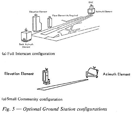
The
full five-element system will in general be needed only at the largest airports.
At most airports the forward azimuth, the elevation and the DME sub-systems will
suffice (Fig. 1) So called Small Community versions (Fig. 5b) providing azimuth
and elevation guidance only can be used at small airports and will serve general
aviation. A matching range of antennas will be needed for these various configurations.
INTERSCAN was developed jointly by the CSIRO and the Department of Transport: Amalgamated Wireless Australasia built the equipment. The project was seen as an Australian contribution to international civil aviation. An important purpose was to ensure that the new system chosen by ICAO will meet Australian requirements. The program was not directed towards commercial objectives but possible benefits to Australian industry were recognised. Australia has now a substantial lead in microwave technologies applied to MLS and has gained much prestige in this field but a great effort is still needed to derive commercial benefits from these assets. Australian industry now faces the task of developing these technologies to the point where equipment is produced that can compete successfully on the world market in price as well as in performance. In preparation for this task the Department of Productivity has since 1976 sponsored work in industry directed towards the commercial exploitation of INTERSCAN. Results have been very promising and it is hoped that Australia's technological success will in due course be followed by commercial success.
The history of INTERSCAN can provide a lesson to Australian scientists and engineers, and should perhaps be written. Suffice it to say here that a crucial factor in the success of the project was the very close collaboration between the three main partners in the program, the Department of Transport, the Radiophysics Division of the CSIRO, and AWA. Co-ordination was achieved with a minimum of paperwork, through face-to-face contact in joint teams and working groups. This permitted the participants to concentrate on their main tasks: Radiophysics on the development of basic concepts and the theoretical infrastructure, the Department of Transport on system operation and ICAO aspects and on field tests, and Industry on hardware.
Approximately $5.5 million was spent on the INTERSCAN project, mainly in industry through the Department of Transport. This sum is small compared with the money spent by others on the development of MLS However the odds facing Australia were not hidden and those responsible for the allocation of large sums to such a project in the face of conflicting demands on an always limited public purse. must be credited with quite some vision. In the event the confidence shown in Australia's engineers and scientists was not misplaced.
About the Author
Egon Stern has worked as an engineer, manager and consultant on aviation navigational systems, in government and industry, since the Second World War. In December 1975 Mr Stern retired from the Department of Transport as Senior Assistant Secretary, and since then he has been employed as a consultant by the Department of Productivity. In May 1978 Mr Stern and the late Sir Donald Anderson were praised in the Australian Senate for their key roles in the development of Interscan.

Postscript
In April 1978 the Australian INTERSCAN MLS was successful in being adopted by ICAO as the standard for future precision instrument approach systems. A lack of interest by Australian companies in marketing the INTERSCAN MLS, plus aggressive American commercial interests saw the system taken over as an 'American' system.
Nevertheless, the great promise of Microwave Landing Systems has never fully materialised. The 60-year-old ILS is still the standard precision instrument approach system worldwide and the great hope for the future is now pinned on precision approaches using satellite navigation systems (e.g. GPS). Nevertheless, MLS has been installed in certain specialised locations where operational requirements have dictated a need for the particular combination of precision and flexibility that, for the moment, only MLS can provide.
Click here to read a history of the development of the INTERSCAN MLS
Back to the main Communications
& Navigation Index
If this page appears without menu bars at top and left, click here