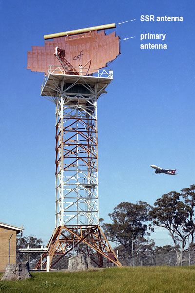
This photo of the Melbourne Route Surveillance Radar (RSR), located on
Radar Hill in the north-western quadrant of Melbourne/Tullamarine Airport,
was taken in 1984. The buildings to the left house the transmitters
and receivers.
This equipment, supplied by French company Compagnie Générale de Télégraphie Sans Fil (CSF - later Thomson-CSF), was the first 'standard' air traffic control radar equipment to be installed in Australia. Previously only experimental radar systems had been used, mostly at Melbourne/Essendon.
The equipment was ordered in December 1960 and the first units were commissoned in August 1963. The first units were installed at Sydney and Adelaide, with Melbourne, Brisbane and Perth also receiving units later. The total cost of the radar installation programme was £2.5 million.
The original equipment was a primary-only radar (Primay Surveillance
Radar - PSR) with a range of 120NM, later increased to 160NM, using
the large reflector antenna seen in the photo above. In the early 1970s
Secondary Surveillance Radar (SSR) capability was added by piggy-backing
the SSR bar antenna on the PSR antenna, as seen above. Click here to
read about the difference between PSR and
SSR.
Radar data was displayed to Controllers on the 'Bright Display' system. In the Bright Display application, only a limited range of non-discrete SSR codes and track symbols was available. The later ATCARDS/AUSCATS system, introduced from 1988, enabled full use of discrete and non-discrete codes.
At airports
with a Radar Approach Service, including Melbourne, a similar Terminal
Area Radar (TAR) was also installed. These units had a shorter range
but a higher rate of rotation, with the resulting higher update rate
permitting a reduction in the radar separation standard for Approach
from 5 or 10NM en route to 3NM.
These radars were replaced commencing in the early 1990s under the Radar Sensor Procurement Programme (RASPP) by lower-powered primary units with a range of 70NM and long-range SSRs with a range of 250NM.
(Photo: CAHS collection)
Examine a chart showing the extent of radar coverage - 1967
Back to the main Communications & Navigation index