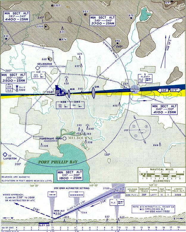
This
detail from a typical instrument approach chart shows the Runway 26 ILS Approach
for Melbourne/Essendon Airport as at 1 May 1968. Note the use of colour and the
depiction of terrain in plan and profile views. The approach minima were 290'/800
yards by day or night. Interestingly, the ILS Localizer back-course is marked
and used for tracking guidance on the missed approach. Use of Localizer back-courses
was subsequently discontinued in Australia.
Comparison with an earlier VAR Approach chart from 1960 reveals the spread of Melbourne's built up area, particularly to the west and north. Essendon Airport, previously located on the fringe of the city, is becoming surrounded - a situation that has led to many problems since.
The Locator for the ILS approach has been shifted from Preston to Plenty (Lower Plenty). Also, the Essendon NDB has been moved from the northern part of the airport to open ground near the threshold of Runway 26. The navaid ident has also changed from ML (Melbourne) to EN (Essendon).
Although not shown for this approach, the Melbourne VAR (located to the north-west of the field) had by this time been replaced by a more versatile VOR. The Airways Markers associated with the VAR (City, Diggers Rest and at the VAR site) have also been decommissioned.
This chart is titled as an 'Essendon' approach, in keeping with the re-naming of the airport itself from 'Melbourne' to 'Essendon'. To the north-west of the field can be seen a symbol marking the new Melbourne/Tullamarine Airport which was then under construction.
By this time, also, long-range radar had been installed and a new Area Approach Control Centre opened providing fully radar-based Approach Control services. This considerably simplified and streamlined terminal operations.
(Chart: Macarthur Job collection. Original 20 x 26.5 cm)
Click here to see a chart showing the layout
of Melbourne/Essendon Airport in 1968
Examine a chart showing the extent of radar coverage - 1967
Back to the main Communications & Navigation index
If
this page appears without menu bars at top and left, click
here