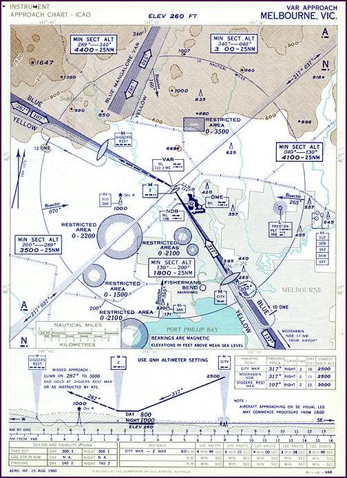
This
typical instrument approach chart shows the VAR
Approach for Melbourne/Essendon Airport as at 15 August 1960.
Of interest is the reliance on VAR as the major radio navigation aid, supplemented by DMEs, NDBs, Locators and Airways Markers. The inbound course of the approach is not aligned with any of the runways, necessitating a circling approach on becoming visual. The approach minima are 540'/2NM by day and 740'/2NM by night. Essendon was also equipped with an ILS for precision instrument approaches.
The Melbourne (ML) VAR was located in open countryside at Tullamarine, near where Melbourne's new airport would be constructed later in the decade. The two visual courses lead to Nhill to the west (Adelaide route), and Cowes to the south (Tasmanian routes). One of the visual courses of the Mangalore VAR can be seen at the top of the chart. Click here to see a detail of this chart and further discussion of its features.
Also of interest is the spread of Melbourne's built up area at the time, indicated by the grey shading toward the bottom of the map section. In later years extensive development would take place, particularly to the north and west in the area shown.
From a chart design point of view, of considerable interest is the use of colour, contours and shading to indicate high ground to the north. Likewise the depiction of terrain height on the procedure profile at the bottom of the chart provides good situational awareness. These depictions of terrain disappeared from instrument approach charts in later years, but in recent times experiments are being made to re-incorporate exactly this kind of information in order to try to prevent 'Controlled Flight Into Terrain' accidents.
(Chart: Macarthur Job collection. Original 20 x 26.5 cm)
Click here to see a chart showing the layout
of Melbourne/Essendon Airport in 1960
Click here to see a later chart showing the Essendon Runway 26 ILS Approach in 1968 for comparison
Click here to see how VARs were shown on en route charts in the 1970s
Back to the main Communications & Navigation index
If
this page appears without menu bars at top and left, click
here